Nova Scotia Archives
Built Heritage Resource Guide
Time Moves On
Many of the sources described in this Resource Guide complement one another, yielding rich detail for re-constructing the built-heritage landscape. For example, researchers exploring the site history of Halifax's World Trade and Convention Centre (1985) on Argyle Street will want to examine photographs, fire insurance plans and city directories — and will be rewarded with small but interlocking details which build into the story of a changing streetscape over time.
W.D. O'Donnell, an early commercial photographer in Halifax, took a photograph about 1887 showing construction of the wall around the Grand Parade, and looking beyond to a number of buildings on the west side of Argyle Street, north of George. A few years later, a photographer from the Notman Studio took another photo of Argyle, showing the streetscape just slightly north of the O'Donnell photograph; City Hall is on the right and several wood-frame and brick buildings are clearly visible on the west side of the street. Moir, Son & Co. is the tall narrow building at the corner of Argyle and Duke, with a horse-drawn delivery wagon outside; and beyond Duke Street is the present site of Scotia Square.
Charles E. Goad's Map of Halifax City, April 1889, identifies the Argyle Street buildings between George and Duke as numbers 94 to 130. McAlpine's City Directory 1889-90 includes an advertisement for Moir, Son & Co., and identifies the business as Bakers and Confectioners, 128 to 132 Argyle (p. 232). The Directory also lists various householders living between George and Duke — a tailor, an 'agent', a sea captain, a physician, a coach driver, post-office clerk, milliner, shoemaker, dressmaker and confectioner — plus two businesses: Moir, Son & Co., of course, and James Knight's Restaurant and Oyster Bar (p. 376).
The streetscape had radically changed by 1941 when photographer E.A. Bollinger also stood in Argyle Street, on almost the same spot as the Notman Studio photographer. By now, Moir's had expanded to occupy the entire block between George and Duke. Cars line the paved street and a 'modern' motorized truck is pulling away from the curb. A few years later still, The Underwriters' Survey Bureau Ltd. identified Moirs Candy Factory, Shipping, Bakery and Offices as a large factory and business complex spread out across 110-128-130 Argyle Street.
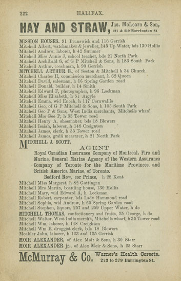
McAlpine's Halifax City Directory for 1885-86
Reference: Nova Scotia Archives Library: F91 H13 M58
Topic: Time Moves On

"The Citadel Hill, Showing Clock-Tower on the Glacis, Halifax"
Date: ca. 1887
Reference: W.D. O'DonnellNova Scotia Archives accession no. 1984-565
Topic: Time Moves On
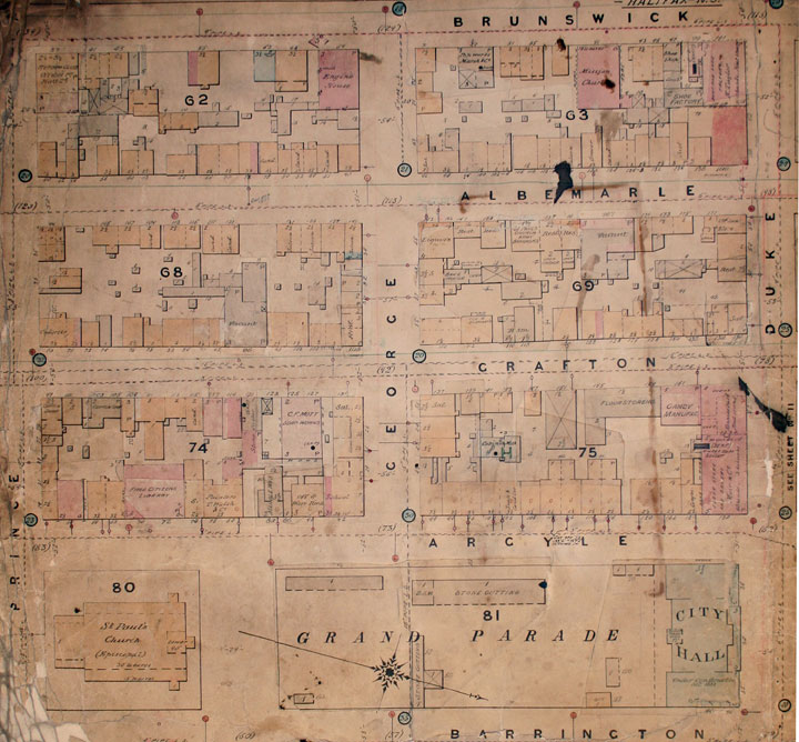
Plate 10, Map of Halifax City
Date: April 1889
Reference: Nova Scotia Archives Map Collection: O/S G1129 H3 G63 1889
Topic: Time Moves On

Argyle Street Looking North from Intersection of George Street
Date: ca. 1892
Photographer: Notman Studio
Reference: Notman StudioNova Scotia Archives no. 6335
Topic: Time Moves On
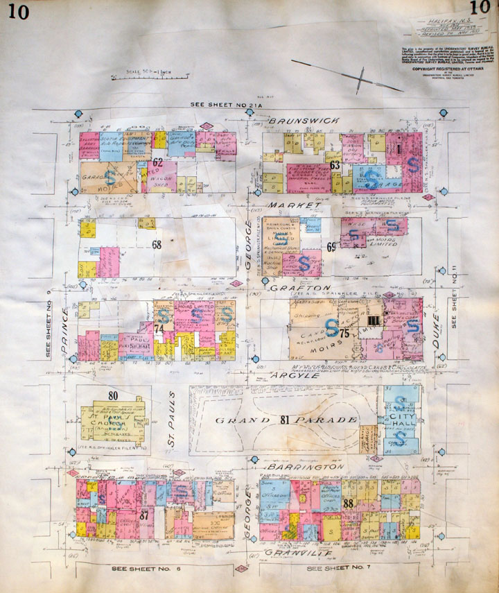
Plate 10, Insurance Plan of the City of Halifax Nova Scotia
Date: Nov. 1914, reprinted July 1949, rev. to Nov. 1951
Reference: Nova Scotia Archives Map Collection: O/S G1129 H3 G63 1949 Vol. 1
Topic: Time Moves On
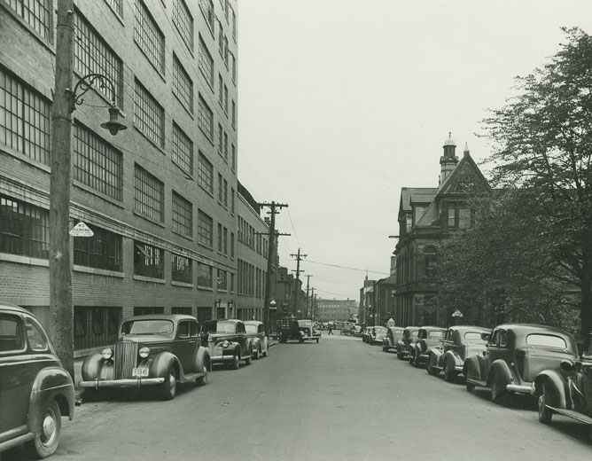
Argyle Street, Halifax, NS
Date: 1941
Photographer: E.A. Bollinger
Reference: Nova Scotia Archives Photo Collection: Places: Halifax: Street Scenes: Argyle
Topic: Time Moves On

Might's 1951 Halifax-Dartmouth City Directories
Reference: Nova Scotia Archives Library: F91 H13 M58
Topic: Time Moves On