Nova Scotia Archives
African Nova Scotian Diaspora
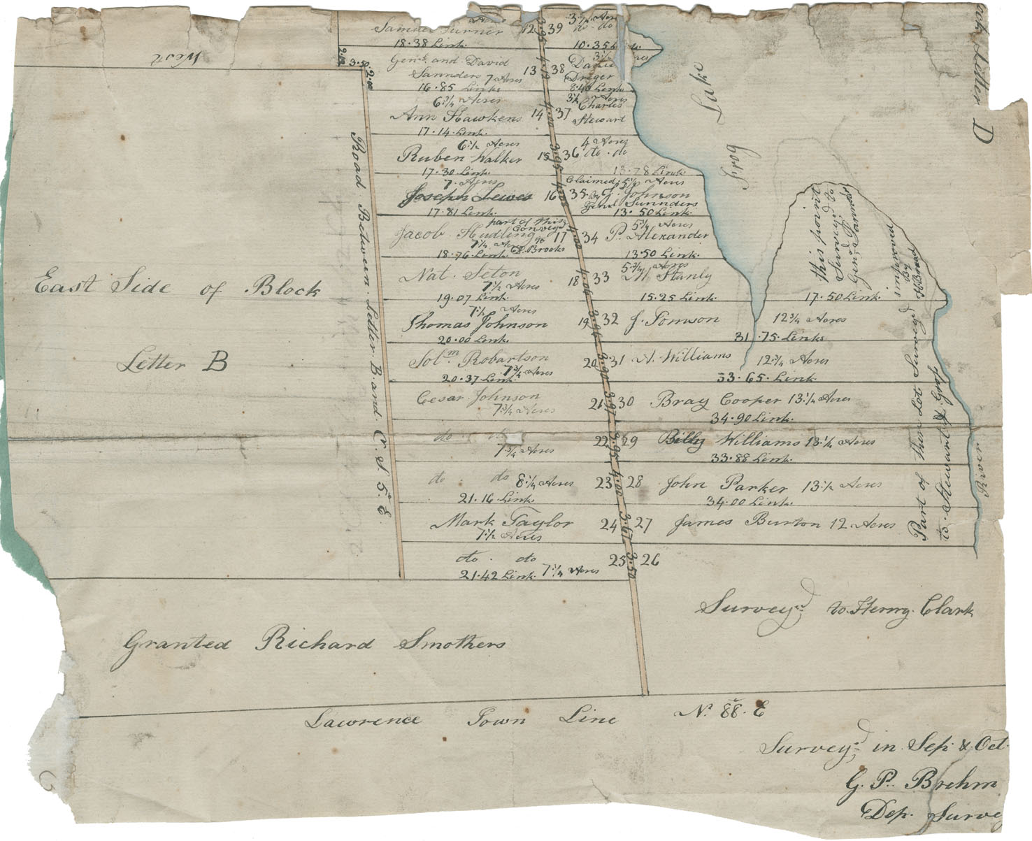
Plan by George P. Brehm of lots occupied by Black people at Preston
note: transcription publicly contributed - please contact us with comments, errors or omisions
[plan of Preston]
12 Samuel Turner 18.38 links 3.95 39
13 GENal and David Sarrnders 7 acres 16.85 links 38
14 6 3/4 Acres Ann Hawkins 17.14 links
15 6 1/2 acres Ruben Walker 17.30 links
16 7 acres Joseph Lewes 17.81 links
17 part of this conveyed Jacob Hudling 7 1/4 acres to P Brooks 18.76 links
18 Nat Seton 7 1/2 acres 19.07 links
19 7 1/2 acres Thomas Johnson 20.00 links
20 SoLm Robartson 7 3/4 acres 20.37 links
21 Cesar Johnson 7 3/4 acres
22 dto dto 7 3/4 acres
23 dto dto 8 1/4 acres 21.16 links
24 Mark Taylor 7 1/2 acres
25 dto dto 7 1/4 acres 21.42 links
26 surveyed to Henry Clark
27 James Burton 12 acres
28 John Parker 13 1/2 acres 34 links
29 Betty Williams 13 1/4 acres 33.88 links
30 Bray Cooper 13 1/4 acres 34.9 links
31 A Williams 12 3/4 acres 33.65 links
32 J [Sorrwon] 12 3/4 acres 31.75 links
33 5 3/4 acres M Stanley 15.25 links
34 P Alexander 5 1/4 acres 13.50 links
35 claimed 5 1/4 acres by J Johnson GeNal Sarrnders 13.50 links
36 4 acres dto dto
37 3 1/4 acres Charles Stewart
38 Danie Dreger 3 1/4 acres 8.4 links
39 3 1/4 acres dto dto 10.35 links
Frog Lake
this point Surveyed to Genal [Sannder]
improved by H. [Broad]
Part of these Lots Surveyed to Stewart [J?] Gross
River
East side of Block Letter B
Road Between letter Band C OF 5 . 6
Granted Richard S mothers
Lawrence town line N 88 E
Survey in Sep & Oct
G.P Brehm
Dep Survey
Date: September and October 1827
Reference: Commissioner of Public Records collection Nova Scotia Archives RG 1 volume 419 number 24

